Bakery nearby Panadería La Fé
Puerto Rico
Bakery nearby Panadería La Fé
Panadería La Fé
contacts phone
:
+1-787
Latitude:
18.186271
, Longitude:
-66.7544227
read more
nearest Bakery
8.684 km
Franjanis Bakery
Carr 123, Utuado
Bakery
read more
10.091 km
Panadería La Utuadeña
Calle Pablo Rosario Yambo, Utuado
Bakery
read more
10.212 km
Golden Donuts
Puerto Rico 123, Utuado
Bakery
read more
10.213 km
Cusa's Party & Cake Shop
Utuado
Bakery
read more
10.357 km
Panadería La Espiga De Plata
87, 79 Calle Doctor Cueto, Utuado
Bakery
read more
10.414 km
La Antigua Bakery
Utuado
Bakery
read more
12.241 km
Panaderia Milly
PR-602, Lares
Bakery
read more
12.797 km
Panadería La Borinqueña eco turismo
Ángeles
Bakery
read more
14.417 km
Panadería Caonillas
PR-613
Bakery
read more
15.081 km
Panaderia La Gran Parada
Lares
Bakery
read more
15.707 km
Morales Bakery
Lares
Bakery
read more
17.385 km
Panadería Doña Sara
Calle Ceiba
Bakery
read more
17.577 km
Paradise Bakery
Lares
Bakery
read more
17.577 km
Panadería El Paraíso
Lares
Bakery
read more
18.374 km
Panadería Altamira
PR-124, Lares
Bakery
read more
19.177 km
Panaderia La Familia
B, 142 Calle Luis Munoz Rivera, Guayanilla
Bakery
read more
19.654 km
Cafe Bakery
#8 Calle 25 De Julio, Yauco
Bakery
read more
20.268 km
Panaderia Y Reposteria El Ensueño
Puerto Rico 129
Bakery
read more
23.334 km
Panaderia Imperial
41 Calle 1, Ponce
Bakery
read more
23.344 km
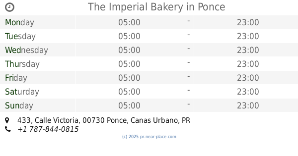
The Imperial Bakery
433 Calle Victoria, Ponce
Bakery
read more
24.06 km
Panaderia Lueguito
119 Calle Guadalupe, Ponce
Bakery
read more
24.56 km
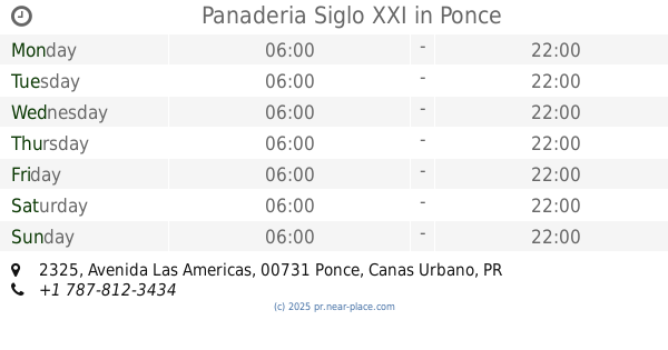
Panaderia Siglo XXI
2325 Avenida Las Americas, Ponce
Bakery
read more
25.101 km
Panaderia y Repostería La Comercio
Ponce
Bakery
read more
27.357 km
Norbit Bakery
00650
Bakery
read more
27.532 km
La Boriqueña
Bakery
read more
📑
all categories
Accounting
Administrative area level 1
Administrative area level 2
Airport
Amusement park
Aquarium
Art gallery
Atm
Bakery
Bank
Bar
Beauty salon
Bicycle store
Book store
Bowling alley
Bus station
Cafe
Campground
Car dealer
Car rental
Car repair
Car wash
Casino
Cemetery
Church
City hall
Clothing store
Colloquial area
Convenience store
Country
Courthouse
Dentist
Department store
Doctor
Electrician
Electronics store
Embassy
Establishment
Finance
Fire station
Florist
Food
Funeral home
Furniture store
Gas station
General contractor
Grocery or supermarket
Gym
Hair care
Hardware store
Health
Hindu Temple
Home goods store
Hospital
Insurance agency
Jewelry store
Laundry
Lawyer
Library
Liquor store
Local government office
Locality
Locksmith
Lodging
Meal delivery
Meal takeaway
Mosque
Movie rental
Movie theater
Moving company
Museum
Natural feature
Neighborhood
Night club
Painter
Park
Parking
Pet store
Pharmacy
Physiotherapist
Place of worship
Plumber
Point of interest
Police
Political
Post office
Premise
Real estate agency
Restaurant
Roofing contractor
Route
Rv park, camping
School
Shoe store
Shopping mall
Spa
Stadium
Storage
Store
Subpremise
Supermarket
Synagogue
Taxi stand
Train station
Transit station
Travel agency
University
Veterinary care
Zoo
sublocality level 1
↑