Bar nearby El Vorcan
Puerto Rico
Bar nearby El Vorcan
El Vorcan
200, Puerto Rico 943, 00778, Gurabo, Gurabo, PR Puerto Rico
contacts phone
:
+1-787
Latitude:
18.2570409
, Longitude:
-65.9726827
larger map & directions
read more
nearest Bar
36 m
Barrita La Oficina
Calle Santiago, Gurabo
Bar
read more
260 m
Rical's Pub And Place And Stuff
Calle 5, Gurabo
Bar
read more
266 m
La esquina de Los Salseros
Gurabo
Bar
read more
604 m
Mickey's Liquor Store and Mini Market
Calle Bahía Oeste, Gurabo
Bar
read more
812 m
Hawks Bar and Grill
Bar
read more
1.567 km
Los Palitos
Bar
read more
1.747 km
Enganchaitos by vieja mesa
Celada
Bar
read more
2.707 km
La Jicotea
Bar
read more
3.048 km
El Campo, Rita y Polo
Celada
Bar
read more
3.322 km
Sector los alamo en gurabo
Calle Los Alamo, Juncos
Bar
read more
3.877 km
El Hijo del Dueño Chinchorro Bar &Grill
Bar
read more
4.207 km
Gurabo
Bar
read more
4.442 km
El Deportivo Sport Bar
Bar
read more
4.631 km
Columpio Bar & Rest.
Unnamed Road, Caguas
Bar
read more
4.802 km
Ojalá
Caguas
Bar
read more
7.713 km
Creolé
136 Calle Gauthier Benitez, Caguas
Bar
read more
8.128 km
Colmado Coco Aleman
Carretera 181, Trujillo Alto
Bar
read more
10.745 km
La Cabaña
Carretera 798 Intersección, Puerto Rico 1, Caguas
Restaurant
Bar
Food
Point of interest
Establishment
read more
11.043 km
El Nuevo Jibarito
Bar
read more
11.287 km
The New Riverside Bar
Caguas
Bar
read more
12.328 km
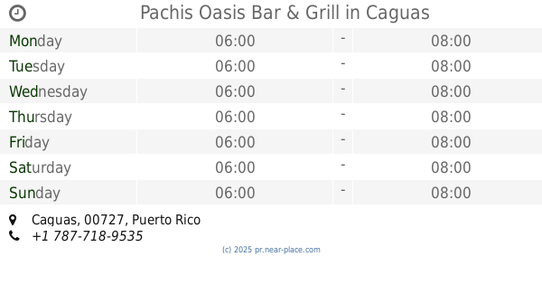
Pachis Oasis Bar & Grill
Caguas
Bar
read more
13.578 km
La Esquina De Tejas
Puerto Rico 183, Las Piedras
Bar
read more
15.995 km
La Bodeguita De Pedro
1761 Avenida Paraná, San Juan
Bar
read more
16.704 km
El Laurel
Puerto Rico 169, Guaynabo
Bar
read more
17.156 km
toñito's sport bar
Puerto Rico, Puerto Rico 787, Cidra
Bar
read more
📑
all categories
Accounting
Administrative area level 1
Administrative area level 2
Airport
Amusement park
Aquarium
Art gallery
Atm
Bakery
Bank
Bar
Beauty salon
Bicycle store
Book store
Bowling alley
Bus station
Cafe
Campground
Car dealer
Car rental
Car repair
Car wash
Casino
Cemetery
Church
City hall
Clothing store
Colloquial area
Convenience store
Country
Courthouse
Dentist
Department store
Doctor
Electrician
Electronics store
Embassy
Establishment
Finance
Fire station
Florist
Food
Funeral home
Furniture store
Gas station
General contractor
Grocery or supermarket
Gym
Hair care
Hardware store
Health
Hindu Temple
Home goods store
Hospital
Insurance agency
Jewelry store
Laundry
Lawyer
Library
Liquor store
Local government office
Locality
Locksmith
Lodging
Meal delivery
Meal takeaway
Mosque
Movie rental
Movie theater
Moving company
Museum
Natural feature
Neighborhood
Night club
Painter
Park
Parking
Pet store
Pharmacy
Physiotherapist
Place of worship
Plumber
Point of interest
Police
Political
Post office
Premise
Real estate agency
Restaurant
Roofing contractor
Route
Rv park, camping
School
Shoe store
Shopping mall
Spa
Stadium
Storage
Store
Subpremise
Supermarket
Synagogue
Taxi stand
Train station
Transit station
Travel agency
University
Veterinary care
Zoo
sublocality level 1
↑