Gas station nearby Junker Mariella
Puerto Rico
Gas station nearby Junker Mariella
Junker Mariella
Lomas Puerto Rico
contacts phone
:
+1-787
Latitude:
18.306738
, Longitude:
-65.9085817
read more
nearest Gas station
1.036 km
Madiel Service Station
Gas station
read more
1.668 km
Gulf Cedros
Gas station
read more
2.353 km
Gasolinera Grace Gas Station
Puerto Rico 185, Juncos
Gas station
read more
4.35 km
Puma
Campo Rico
Gas station
read more
4.408 km
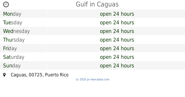
Gulf
Campo Rico
Gas station
read more
8.622 km
Shell
Av. 65 de Infantería, Trujillo Bajo
Gas station
read more
8.767 km
Shell
PR-3 W
Gas station
read more
9.203 km
Shell
Puerto Rico 189, Gurabo
Gas station
read more
11.574 km
Total PR
PR- 887, Km. 2.0, San Anton, Carolina
Gas station
read more
11.788 km
Shell
PR-848, Carolina
Gas station
read more
11.932 km
Puma Gas Station
Gas station
read more
12.079 km
Puma
Avenida José Fidalgo Díaz, Carolina
Gas station
read more
12.686 km
Puma
Gurabo
Gas station
read more
13.281 km
Total Carretera 189
Puerto Rico 189, Caguas
Gas station
read more
14.06 km
Gasolinera Shell
187 Calle Barbosa, Las Piedras
Gas station
read more
14.098 km
Total
Calle José Celso Barbosa, Las Piedras
Gas station
read more
14.652 km
Gulf
Caguas
Gas station
read more
14.697 km
Total
Carr. 183 Km. 10.8, San Lorenzo
Gas station
read more
14.791 km
Tire Depot & Truck Services
Carretera 183, San Lorenzo
Gas station
read more
15.186 km
Shell
Avenida Jorge Vazques Sanes, Vasquez Sanes
Gas station
read more
15.301 km
Puma Cupey Gas
San Juan
Gas station
read more
15.58 km
Gulf
18-20 Calle Georgetti, Caguas
Gas station
read more
16.331 km
Puma
153,, Avenida Gautier Benítez, Caguas
Gas station
read more
16.47 km
Total Gautier Benitez
Calle Gautier Benitez #160- Cayey a Caguas, Caguas
Gas station
read more
17.254 km
Shell
1 Avenida Degetau, Caguas
Gas station
read more
📑
all categories
Accounting
Administrative area level 1
Administrative area level 2
Airport
Amusement park
Aquarium
Art gallery
Atm
Bakery
Bank
Bar
Beauty salon
Bicycle store
Book store
Bowling alley
Bus station
Cafe
Campground
Car dealer
Car rental
Car repair
Car wash
Casino
Cemetery
Church
City hall
Clothing store
Colloquial area
Convenience store
Country
Courthouse
Dentist
Department store
Doctor
Electrician
Electronics store
Embassy
Establishment
Finance
Fire station
Florist
Food
Funeral home
Furniture store
Gas station
General contractor
Grocery or supermarket
Gym
Hair care
Hardware store
Health
Hindu Temple
Home goods store
Hospital
Insurance agency
Jewelry store
Laundry
Lawyer
Library
Liquor store
Local government office
Locality
Locksmith
Lodging
Meal delivery
Meal takeaway
Mosque
Movie rental
Movie theater
Moving company
Museum
Natural feature
Neighborhood
Night club
Painter
Park
Parking
Pet store
Pharmacy
Physiotherapist
Place of worship
Plumber
Point of interest
Police
Political
Post office
Premise
Real estate agency
Restaurant
Roofing contractor
Route
Rv park, camping
School
Shoe store
Shopping mall
Spa
Stadium
Storage
Store
Subpremise
Supermarket
Synagogue
Taxi stand
Train station
Transit station
Travel agency
University
Veterinary care
Zoo
sublocality level 1
↑