Park nearby Paseo Mirador
Puerto Rico
Park nearby Paseo Mirador
Paseo Mirador
Carr 156 R, 00725, Caguas, Aguas Buenas, PR Puerto Rico
contacts phone
:
+1-787
Latitude:
18.2568344
, Longitude:
-66.1070194
larger map & directions
read more
nearest Park
174 m
Parque MUNICIPAL MANOLO FONTANES
Puerto Rico 174, Aguas Buenas
Park
read more
174 m
Parque AA aguas buenas
Puerto Rico 174, Aguas Buenas
Park
read more
429 m
Plaza Pública
Aguas Buenas
Park
read more
2.273 km
Cagüitas Park
Park
read more
3.435 km
Parque Forestal La Marquesa
Park
read more
4.087 km
La Marquesa Forest Park
Puerto Rico 834
Park
Point of interest
Establishment
read more
4.398 km
Parque Forestal La Marquesa
Puerto Rico 834, Guaynabo
Park
read more
4.457 km
Children's Park
Caguas
Park
read more
4.533 km
Parque Pozo Dulce
Park
read more
5.133 km
Jardin Botanico y Cultural de Caguas
Puerto Rico 156, Caguas
Park
read more
5.133 km
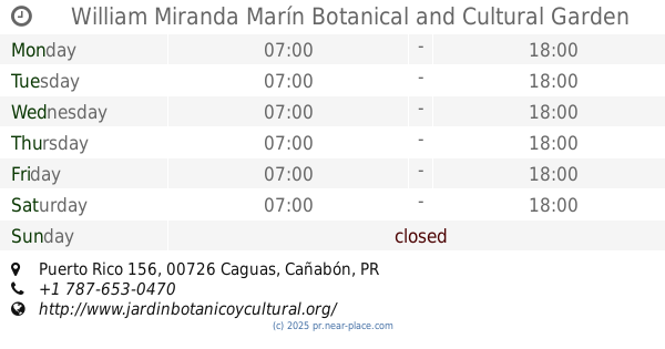
Jardín Botánico y Cultural de Caguas William Miranda Marín
Puerto Rico 156, Caguas
Park
read more
5.133 km
William Miranda Marín Botanical and Cultural Garden
Puerto Rico 156, Caguas
Park
Point of interest
Establishment
read more
6.322 km
Parque Pelota Turabo Garden
Caguas
Park
read more
7.369 km
Hacienda Mí Remanso
Park
read more
7.839 km
Piscina De CAGUAS
Caguas
Park
read more
8.309 km
Sede ACBPR (Polideportivo)
Calle Luxemburgo, Caguas
Park
read more
12.7 km
Parque Los Guamas
Guaynabo
Park
read more
13.536 km
Parque Comerio
1-25 Calle 1, Comerío
Park
read more
13.79 km
Parque Naranja
Monacillo Urbano
Park
read more
14.068 km
Parque Recreativo Rio Bayamón
Calle 2, Bayamón
Park
read more
14.568 km
Parque Santiago Iglesias
Monacillo Urbano
Park
read more
14.916 km
Parque Jose 'Pepito' Rivera
Avenida Magnolia, Bayamón
Park
read more
15.032 km
Parque La Loma
Park
read more
15.313 km
Cerro piñas arriba
PR-775, Comerío
Campground
Lodging
Park
Point of interest
Establishment
read more
16.049 km
Parque Miraflores
Calle 53, Bayamón
Park
read more
📑
all categories
Accounting
Administrative area level 1
Administrative area level 2
Airport
Amusement park
Aquarium
Art gallery
Atm
Bakery
Bank
Bar
Beauty salon
Bicycle store
Book store
Bowling alley
Bus station
Cafe
Campground
Car dealer
Car rental
Car repair
Car wash
Casino
Cemetery
Church
City hall
Clothing store
Colloquial area
Convenience store
Country
Courthouse
Dentist
Department store
Doctor
Electrician
Electronics store
Embassy
Establishment
Finance
Fire station
Florist
Food
Funeral home
Furniture store
Gas station
General contractor
Grocery or supermarket
Gym
Hair care
Hardware store
Health
Hindu Temple
Home goods store
Hospital
Insurance agency
Jewelry store
Laundry
Lawyer
Library
Liquor store
Local government office
Locality
Locksmith
Lodging
Meal delivery
Meal takeaway
Mosque
Movie rental
Movie theater
Moving company
Museum
Natural feature
Neighborhood
Night club
Painter
Park
Parking
Pet store
Pharmacy
Physiotherapist
Place of worship
Plumber
Point of interest
Police
Political
Post office
Premise
Real estate agency
Restaurant
Roofing contractor
Route
Rv park, camping
School
Shoe store
Shopping mall
Spa
Stadium
Storage
Store
Subpremise
Supermarket
Synagogue
Taxi stand
Train station
Transit station
Travel agency
University
Veterinary care
Zoo
sublocality level 1
↑