Restaurant nearby Burriburger
Puerto Rico
Restaurant nearby Burriburger
Burriburger
contacts phone
:
+1-787
Latitude:
18.0003057
, Longitude:
-66.626834
read more
nearest Restaurant
368 m
SUBWAY®Restaurants
Ponce Mall Shopping Center, Space #1, Ponce
Restaurant
read more
451 m
Tasty Chicken & Ribs II
2325 Boulevard Luis A. Ferre, Ponce
Restaurant
read more
497 m
Popeyes Louisiana Kitchen
Popeyes Chicken & Biscuits, Calle Cándido Hoyos, Ponce
Restaurant
read more
529 m
Bonanza
Ponce
Restaurant
read more
536 m
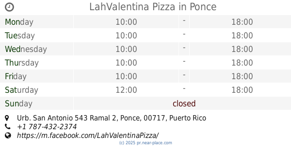
LahValentina Pizza
Urb. San Antonio 543 Ramal 2, Ponce
Restaurant
read more
558 m
Las 7 Potencias Ponce
2643 Ponce Bypass, Ponce
Restaurant
read more
568 m
Taco Bell
Ponce Bypass, Ponce
Restaurant
read more
598 m
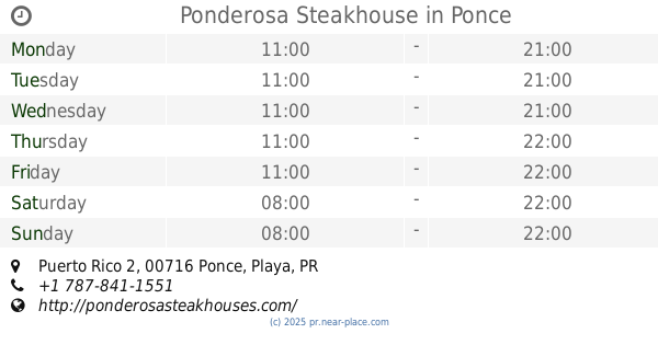
Ponderosa Steakhouse
Carretera Puerto Rico 2, Ponce
Restaurant
read more
598 m
Ponderosa Steakhouse
Puerto Rico 2, Ponce
Restaurant
read more
633 m
Cafetería Sabores
Puerto Rico 2R, Ponce
Restaurant
read more
666 m
Pizza Chef's
2196 Boulevard Luis A. Ferre, Ponce
Restaurant
read more
702 m
New York Style Pizza
Ponce
Restaurant
read more
713 m
CrepeMaker
Ponce Bypass, Ponce
Restaurant
read more
719 m
Gaby Mini Donas
2188 Avenida Eduardo Ruberte, Ponce
Restaurant
read more
726 m
China Garden
Ponce
Restaurant
read more
754 m
Punto 7
Restaurant
read more
755 m
Carreton Los Amigos
Paseo Perla del Sur, Ponce
Restaurant
read more
789 m
Tasty
Calle Capitan Correa, Ponce
Restaurant
read more
796 m
Pizza Hut
Restaurant
read more
989 m
Subway
2213 Ponce By Pass, First Floor, Hospital Damas, Ponce
Restaurant
read more
989 m
SUBWAY®Restaurants
2213 Ponce By Pass, First Floor, Hospital Damas, Ponce
Restaurant
read more
989 m
Subway Restaurants
2213 Ponce By Pass, First Floor, Hospital Damas, Ponce
Restaurant
read more
1.007 km
Subway
405 Ferrocaril St, # 14C, Santa Maria Shopping Ctr, Ponce
Restaurant
read more
1.025 km
Little Caesars Pizza
Santa María Shopping Center, Calle Ferrocarri, Ponce
Restaurant
read more
1.112 km
Cafeteria Torres
73-89 Avenida Roosevelt, Ponce
Restaurant
read more
📑
all categories
Accounting
Administrative area level 1
Administrative area level 2
Airport
Amusement park
Aquarium
Art gallery
Atm
Bakery
Bank
Bar
Beauty salon
Bicycle store
Book store
Bowling alley
Bus station
Cafe
Campground
Car dealer
Car rental
Car repair
Car wash
Casino
Cemetery
Church
City hall
Clothing store
Colloquial area
Convenience store
Country
Courthouse
Dentist
Department store
Doctor
Electrician
Electronics store
Embassy
Establishment
Finance
Fire station
Florist
Food
Funeral home
Furniture store
Gas station
General contractor
Grocery or supermarket
Gym
Hair care
Hardware store
Health
Hindu Temple
Home goods store
Hospital
Insurance agency
Jewelry store
Laundry
Lawyer
Library
Liquor store
Local government office
Locality
Locksmith
Lodging
Meal delivery
Meal takeaway
Mosque
Movie rental
Movie theater
Moving company
Museum
Natural feature
Neighborhood
Night club
Painter
Park
Parking
Pet store
Pharmacy
Physiotherapist
Place of worship
Plumber
Point of interest
Police
Political
Post office
Premise
Real estate agency
Restaurant
Roofing contractor
Route
Rv park, camping
School
Shoe store
Shopping mall
Spa
Stadium
Storage
Store
Subpremise
Supermarket
Synagogue
Taxi stand
Train station
Transit station
Travel agency
University
Veterinary care
Zoo
sublocality level 1
↑