Restaurant nearby Cantinflas Caguas
Puerto Rico
Restaurant nearby Cantinflas Caguas
Cantinflas Caguas
Aguada, 00602, Puerto Rico
contacts phone
:
+1-787
Latitude:
18.3793913
, Longitude:
-67.1882365
larger map & directions
read more
nearest Restaurant
163 m
The Taco Maker
Avenida Nativo Alers, Aguada
Restaurant
read more
166 m
Casa Linda Panoramoc Restaurant
Puerto Rico
Restaurant
read more
176 m
Jalapeños
101-, 107 Calle Doctor Carlos Gonzalez, Aguada
Restaurant
read more
189 m
SUBWAY®Restaurants
Aguada Town Center, Ave. Nativo Alers Desvio Sur, Aguada
Restaurant
read more
189 m
Subway
Aguada Town Center, Ave. Nativo Alers Desvio Sur, Aguada
Restaurant
read more
213 m
ND Breakfast
Avenida Nativo Alers, Aguada
Restaurant
read more
224 m
El Chapo Burger
262-298 Calle Cristóbal Colón, Aguada
Restaurant
read more
228 m
Chili's Fried Chicken
Restaurant
read more
236 m
Picnic & Grill
Aguada
Restaurant
read more
237 m
Juny’s Pinchos
Restaurant
read more
258 m
The Lunch Box
275 Calle Paz, Aguada
Restaurant
read more
263 m
Red Trees
Avenida Nativo Alers, Aguada
Restaurant
read more
310 m
Cano's Hot Dog & Grill
Avenida Nativo Alers, Aguada
Restaurant
read more
312 m
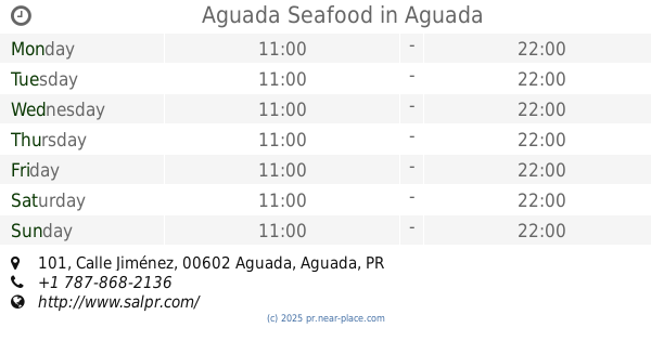
Aguada Seafood
199, 101 Calle Jiménez, Aguada
Restaurant
read more
370 m
Green Aura
131 Calle Colon, Aguada
Restaurant
read more
374 m
Sazón D' Madre
Calle B, Aguada
Restaurant
read more
471 m
Big Cherky's Pitzza
Calle Estacion, Aguada
Restaurant
read more
680 m
Lochos Cafe
Avenida Nativo Alers
Restaurant
read more
723 m
Tonito’s Pizza
Restaurant
read more
749 m
Ibiza
Avenida Nativo Alers, Aguada
Restaurant
read more
765 m
Cheche's Grill
12 Puerto Rico 115, Aguada
Restaurant
read more
810 m
D&Y Hot Potatoes
Puerto Rico 115, Aguada
Restaurant
read more
810 m
D & Y Hot Potatoes
Puerto Rico 115, Aguada
Restaurant
read more
933 m
Antonino's Pizza Aguada
Aguada Shoping Center Aguada, Puerto Rico
Restaurant
read more
955 m
McDonald's
Puerto Rico 115, Aguada
Restaurant
read more
📑
all categories
Accounting
Administrative area level 1
Administrative area level 2
Airport
Amusement park
Aquarium
Art gallery
Atm
Bakery
Bank
Bar
Beauty salon
Bicycle store
Book store
Bowling alley
Bus station
Cafe
Campground
Car dealer
Car rental
Car repair
Car wash
Casino
Cemetery
Church
City hall
Clothing store
Colloquial area
Convenience store
Country
Courthouse
Dentist
Department store
Doctor
Electrician
Electronics store
Embassy
Establishment
Finance
Fire station
Florist
Food
Funeral home
Furniture store
Gas station
General contractor
Grocery or supermarket
Gym
Hair care
Hardware store
Health
Hindu Temple
Home goods store
Hospital
Insurance agency
Jewelry store
Laundry
Lawyer
Library
Liquor store
Local government office
Locality
Locksmith
Lodging
Meal delivery
Meal takeaway
Mosque
Movie rental
Movie theater
Moving company
Museum
Natural feature
Neighborhood
Night club
Painter
Park
Parking
Pet store
Pharmacy
Physiotherapist
Place of worship
Plumber
Point of interest
Police
Political
Post office
Premise
Real estate agency
Restaurant
Roofing contractor
Route
Rv park, camping
School
Shoe store
Shopping mall
Spa
Stadium
Storage
Store
Subpremise
Supermarket
Synagogue
Taxi stand
Train station
Transit station
Travel agency
University
Veterinary care
Zoo
sublocality level 1
↑