Restaurant nearby Deje De Sufrir
Puerto Rico
Restaurant nearby Deje De Sufrir
Deje De Sufrir
Puerto Rico 174, Bayamón Puerto Rico
contacts phone
:
+1-787
Latitude:
18.3259979
, Longitude:
-66.1417281
read more
nearest Restaurant
424 m
Pizzeria Rojoli
Puerto Rico 174, Bayamón
Restaurant
read more
736 m
Nieves BBQ
Carretera 174 Km 5.5, Puerto Rico 174, Bayamón
Restaurant
read more
904 m
Pizza Conos
00957,
Restaurant
read more
1.434 km
Forestry Crops
Sector Chinea, Carretera 174 Kilometro 10.0
Campground
Lodging
Park
Restaurant
Food
School
Point of interest
Establishment
read more
1.91 km
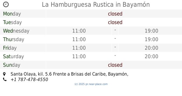
La Hamburguesa Rustica
Santa Olaya, kil. 5.6 Frente a Brisas del Caribe, Bayamón
Restaurant
read more
1.913 km
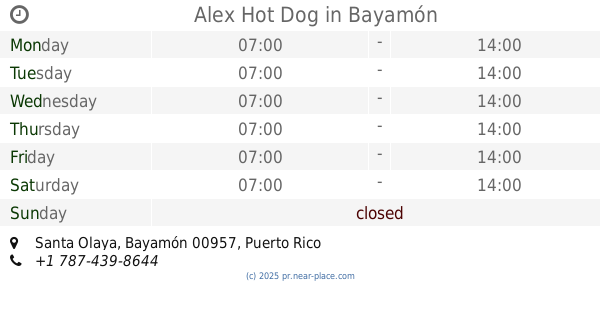
Alex Hot Dog
Restaurant
read more
1.974 km
Lechonera Brisas del Caribe
Puerto Rico 830
Restaurant
read more
2.08 km
Pizzeria Santa Olaya
Puerto Rico 829, Bayamón
Restaurant
read more
2.082 km
Del Campo B.B.Q
Restaurant
read more
2.083 km
Alcapurrias Del Campo
Puerto Rico 836, Guaynabo
Restaurant
read more
2.153 km
Panadería Las Americas
Calle 3
Restaurant
read more
2.32 km
El Chiringo
Carretera 831, Bayamón
Restaurant
read more
2.349 km
El Hp Burguer
Restaurant
read more
2.356 km
HP Sobre Ruedas
Puerto Rico 829, Bayamón
Restaurant
read more
2.375 km
El Pez Oscar
Restaurant
read more
2.538 km
Hacienda O'Neill
Guaynabo
Restaurant
read more
2.563 km
La Frontera, Alcapurias y Almuerzos
Puerto Rico 830, Bayamón
Restaurant
read more
2.645 km
La CasIta De Ingrid
831 km 4.9, Bayamón
Restaurant
read more
2.676 km
El Rincon De Pito
Puerto Rico 174, Bayamón
Restaurant
read more
2.81 km
La Cocina de Rinolfia
00957
Restaurant
read more
2.944 km
El Rabioso
13 Cll Oriente, Bayamón
Restaurant
read more
2.977 km
La Cociina De Barbiie
Calle Mizar, Bayamón
Restaurant
read more
2.995 km
Las Empanadillas Famosas
Avenue Irlanda, Bayamón
Restaurant
read more
3.057 km
Babby's Pinchos
Avenue Irlanda, Bayamón
Restaurant
read more
3.324 km
Junior "Peye" B.B.Q.
Carr. 831 Km 3.8, Bo. Minillas, Bayamón
Restaurant
read more
📑
all categories
Accounting
Administrative area level 1
Administrative area level 2
Airport
Amusement park
Aquarium
Art gallery
Atm
Bakery
Bank
Bar
Beauty salon
Bicycle store
Book store
Bowling alley
Bus station
Cafe
Campground
Car dealer
Car rental
Car repair
Car wash
Casino
Cemetery
Church
City hall
Clothing store
Colloquial area
Convenience store
Country
Courthouse
Dentist
Department store
Doctor
Electrician
Electronics store
Embassy
Establishment
Finance
Fire station
Florist
Food
Funeral home
Furniture store
Gas station
General contractor
Grocery or supermarket
Gym
Hair care
Hardware store
Health
Hindu Temple
Home goods store
Hospital
Insurance agency
Jewelry store
Laundry
Lawyer
Library
Liquor store
Local government office
Locality
Locksmith
Lodging
Meal delivery
Meal takeaway
Mosque
Movie rental
Movie theater
Moving company
Museum
Natural feature
Neighborhood
Night club
Painter
Park
Parking
Pet store
Pharmacy
Physiotherapist
Place of worship
Plumber
Point of interest
Police
Political
Post office
Premise
Real estate agency
Restaurant
Roofing contractor
Route
Rv park, camping
School
Shoe store
Shopping mall
Spa
Stadium
Storage
Store
Subpremise
Supermarket
Synagogue
Taxi stand
Train station
Transit station
Travel agency
University
Veterinary care
Zoo
sublocality level 1
↑