School nearby Cuido Sobrino
Puerto Rico
School nearby Cuido Sobrino
Cuido Sobrino
2-10, Calle 2 East, Bayamón Puerto Rico
contacts phone
:
+1-787
Latitude:
18.4158441
, Longitude:
-66.1770973
read more
nearest School
144 m
Escuela José Julián Tapia de La Rosa
Calle 2 West, Bayamón
School
read more
851 m
Centro Cristiano Vida Abundante Bayamon
Bayamón
School
read more
872 m
Colegio Zaenid
Hato Tejas, Bayamón
School
read more
877 m
Colegio Zaenid
Calle 10, Bayamón
School
read more
900 m
Unlimited Models
Bayamón
School
read more
926 m
CN CC
Calle 1, Bayamón
School
read more
977 m
Centro Pre-escolar Precious Kids
Bayamón
School
read more
1.006 km
Bayamón Military Academy
Expreso José De Diego, Bayamón
School
read more
1.04 km
Nataciones Yarismar
Cll Río Jajome South, Bayamón
School
read more
1.052 km
Llegando a Bayamón Military Academy
Carr Volcan, Bayamón
School
read more
1.082 km
Automeca
Marcador colocado cerca de, Bayamón
School
read more
1.084 km
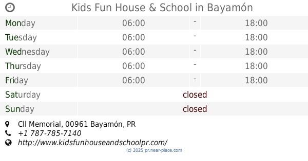
Kids Fun House & School
Cll Memorial, Bayamón
School
read more
1.089 km
Escuela Especializada En Cinematografía Cacique Agueybana Secundaria
Bayamón
School
read more
1.118 km
Esc. Maria Teresa Piñeiro
Calle Los Marquez, Bayamón
School
read more
1.143 km
Carretera Del Volcan
17 Calle 19, Bayamón
School
read more
1.174 km
Cacique Agüeybana School
69 Calle 61, Bayamón
School
read more
1.189 km
Departamento Educación Bayamón II
69 Calle 61, Bayamón
School
read more
1.212 km
Soccerfive
42-52 Cll Río Espiritu Santo South, Bayamón
School
read more
1.375 km
Escuela Juan Ramon Jimenez
Calle Pluma, Bayamón
School
read more
1.464 km
Centro De Desarrollo Del Niño Trópico
Calle Río Bayamón, Bayamón
School
read more
1.472 km
First School Bilingue
112 Carretera Hato Tejas, Bayamón
School
read more
1.619 km
Escuela Elemental Virgilio Davila
Puerto Rico 864, Bayamón
School
read more
1.659 km
Colegio Y Cuido
Hato Tejas
School
read more
1.754 km
Salon Del Reino Valencia
Calle Pablo R. Salas, Bayamón
School
read more
2.682 km
Escuela Superior
Bayamón
School
read more
📑
all categories
Accounting
Administrative area level 1
Administrative area level 2
Airport
Amusement park
Aquarium
Art gallery
Atm
Bakery
Bank
Bar
Beauty salon
Bicycle store
Book store
Bowling alley
Bus station
Cafe
Campground
Car dealer
Car rental
Car repair
Car wash
Casino
Cemetery
Church
City hall
Clothing store
Colloquial area
Convenience store
Country
Courthouse
Dentist
Department store
Doctor
Electrician
Electronics store
Embassy
Establishment
Finance
Fire station
Florist
Food
Funeral home
Furniture store
Gas station
General contractor
Grocery or supermarket
Gym
Hair care
Hardware store
Health
Hindu Temple
Home goods store
Hospital
Insurance agency
Jewelry store
Laundry
Lawyer
Library
Liquor store
Local government office
Locality
Locksmith
Lodging
Meal delivery
Meal takeaway
Mosque
Movie rental
Movie theater
Moving company
Museum
Natural feature
Neighborhood
Night club
Painter
Park
Parking
Pet store
Pharmacy
Physiotherapist
Place of worship
Plumber
Point of interest
Police
Political
Post office
Premise
Real estate agency
Restaurant
Roofing contractor
Route
Rv park, camping
School
Shoe store
Shopping mall
Spa
Stadium
Storage
Store
Subpremise
Supermarket
Synagogue
Taxi stand
Train station
Transit station
Travel agency
University
Veterinary care
Zoo
sublocality level 1
↑