School nearby X M E Studio
Puerto Rico
School nearby X M E Studio
X M E Studio
Calle de Barbosa, Bayamón Puerto Rico
contacts phone
:
+1-787
Latitude:
18.3991353
, Longitude:
-66.1540876
read more
nearest School
157 m
Centro De Estudios Multidisciplinarios Bayamon
31, 11 Calle Degetau, Bayamón
School
read more
189 m
Centro Head Start Pueblito
29 Calle de Barbosa, Bayamón
School
read more
249 m
Escuela De Bellas Artes De Bayamón
Bayamón
School
read more
250 m
Edutec
28 Calle Santa Cruz, Bayamón
School
read more
267 m
Pininos Day Care
18°24'02."N 66°09'."W, 21
School
read more
289 m
Complejo Onofre
Bayamón
School
read more
294 m
Puerto Rico Partners School
Calle Doctor Ferrer, Bayamón
School
read more
297 m
GUARANTEE DRIVING SCHOOL
Bayamón
School
read more
353 m
AMEDCO Bayamón
45 Calle Santa Cruz, Bayamón
School
read more
495 m
Escuela Superior
Bayamón
School
read more
554 m
ITECH INSTITUTE
117 Calle Doctor Santiago Veve, Bayamón
School
read more
577 m
Escuela Superior Agustin Stahl
Calle Betances, Bayamón
School
read more
577 m
Dr. Agustín Stahl High School
Calle Betances, Bayamón
School
read more
616 m
Institución Educativa Nets, LLC
84-11 Calle 70, Bayamón
School
read more
804 m
Escuela Muñoz Rivera
Puerto Rico 855, Bayamón
School
read more
876 m
Stereotecnia
Puerto Rico 174, Bayamón
School
read more
977 m
Escuela José Antonio Dávila
Bayamón
School
read more
986 m
Escuela Dr. José Antonio Dávila
Calle Marginal, Bayamón
School
Point of interest
Establishment
read more
1.096 km
Colegio Emadrian
-19 Puerto Rico, 12 Calle 7, Bayamón
School
read more
1.339 km
Escuela Braulio Dueño Colón
Calle 4, Bayamón
School
read more
1.481 km
Colegio Y Cuido
Hato Tejas
School
read more
1.553 km
Escuela Luis Palés Matos
Calle 11, Bayamón
School
read more
1.739 km
La Liga Bíblica de Puerto Rico
H-127 Calle Atenas, Bayamón
School
read more
1.988 km
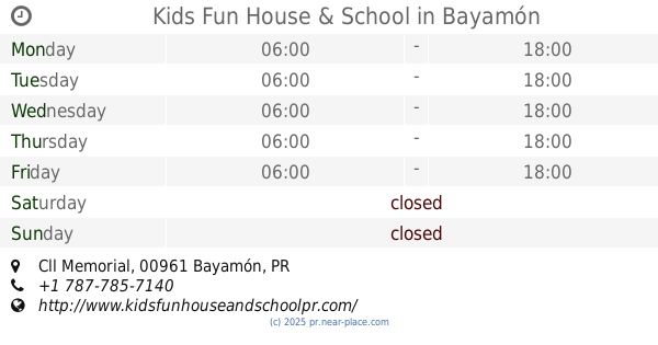
Kids Fun House & School
Cll Memorial, Bayamón
School
read more
2.633 km
Escuela Pedro J. Rodriguez
859 Puerto Rico 839, Bayamón
School
read more
📑
all categories
Accounting
Administrative area level 1
Administrative area level 2
Airport
Amusement park
Aquarium
Art gallery
Atm
Bakery
Bank
Bar
Beauty salon
Bicycle store
Book store
Bowling alley
Bus station
Cafe
Campground
Car dealer
Car rental
Car repair
Car wash
Casino
Cemetery
Church
City hall
Clothing store
Colloquial area
Convenience store
Country
Courthouse
Dentist
Department store
Doctor
Electrician
Electronics store
Embassy
Establishment
Finance
Fire station
Florist
Food
Funeral home
Furniture store
Gas station
General contractor
Grocery or supermarket
Gym
Hair care
Hardware store
Health
Hindu Temple
Home goods store
Hospital
Insurance agency
Jewelry store
Laundry
Lawyer
Library
Liquor store
Local government office
Locality
Locksmith
Lodging
Meal delivery
Meal takeaway
Mosque
Movie rental
Movie theater
Moving company
Museum
Natural feature
Neighborhood
Night club
Painter
Park
Parking
Pet store
Pharmacy
Physiotherapist
Place of worship
Plumber
Point of interest
Police
Political
Post office
Premise
Real estate agency
Restaurant
Roofing contractor
Route
Rv park, camping
School
Shoe store
Shopping mall
Spa
Stadium
Storage
Store
Subpremise
Supermarket
Synagogue
Taxi stand
Train station
Transit station
Travel agency
University
Veterinary care
Zoo
sublocality level 1
↑