Atm nearby ATH
Puerto Rico
Atm nearby ATH
ATH
1900 Carretera 167, Bayamón Puerto Rico
contacts phone
:
+1-787
Latitude:
18.3407897
, Longitude:
-66.2034156
read more
nearest Atm
139 m
ATM First Bank
1900 Carretera 167, Bayamón
Atm
read more
2.689 km
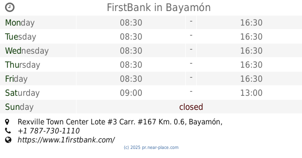
FirstBank
Rexville Town Center Lote #3 Carr. #167 Km. 0.6, Bayamón
Bank
Atm
Finance
Point of interest
Establishment
read more
2.748 km
ATM Banco Popular
Bayamón
Atm
read more
3.124 km
ATM Scotiabank
Bayamón
Atm
read more
3.329 km
Atm (Arcoop)
Bayamón
Atm
read more
5.059 km
Nationallink, Inc.
Centro Commercial 167, Bayamon, PR
Atm
read more
5.724 km
EZ Payments Inc.
Minillas Gas Station, Bayamon, PR
Atm
read more
5.814 km
Banco Popular ATM
Atm
read more
6.24 km
EZ Payments Inc.
Farmacia Naranjito, Naranjito, PR 00719
Atm
read more
6.291 km
Cajero Automatico Banco Popular
Naranjito
Atm
read more
6.497 km
Scotiabank ATM
Bayamón
Atm
read more
7.723 km
ATM Oriental Bank Minillas
Puerto Rico 174, Bayamón
Atm
read more
9.924 km
EZ Payments Inc.
Supermeercado Diaz, Guaynabo, PR
Atm
read more
10.243 km
ATM First Bank
Bayamón
Atm
read more
11.162 km
ATH Banco Popular
7006, Puerto Rico 693, Dorado
Atm
read more
12.371 km
ATM
Puerto Rico 21, San Juan
Atm
read more
12.57 km
ATM
Calle Tabonuco, Guaynabo
Atm
read more
12.643 km
ATM
Puerto Rico 838, San Juan
Atm
read more
14.862 km
Banco Popular
Dorado
Atm
read more
15.43 km
ATM Scotiabank
Carr. PR-693 Int. PR 696 Dorado, Puerto Rico
Atm
read more
16.47 km
Cajero ATH
Avendia Carlos E. Chardón, San Juan
Atm
read more
17.976 km
Oriental Bank - Trust ATM
Avenida Juan Ponce de León, San Juan
Atm
read more
18.121 km
BPPR ATH
Atm
read more
18.911 km
FirstBank
#1161 Avenida Ashford Esq, Condado Avenue, Condado
Bank
Atm
Finance
Point of interest
Establishment
read more
19.115 km
ATM Popular PR
18°27'05. 66°03'53., 8"N Calle 6, San Juan
Atm
read more
📑
all categories
Accounting
Administrative area level 1
Administrative area level 2
Airport
Amusement park
Aquarium
Art gallery
Atm
Bakery
Bank
Bar
Beauty salon
Bicycle store
Book store
Bowling alley
Bus station
Cafe
Campground
Car dealer
Car rental
Car repair
Car wash
Casino
Cemetery
Church
City hall
Clothing store
Colloquial area
Convenience store
Country
Courthouse
Dentist
Department store
Doctor
Electrician
Electronics store
Embassy
Establishment
Finance
Fire station
Florist
Food
Funeral home
Furniture store
Gas station
General contractor
Grocery or supermarket
Gym
Hair care
Hardware store
Health
Hindu Temple
Home goods store
Hospital
Insurance agency
Jewelry store
Laundry
Lawyer
Library
Liquor store
Local government office
Locality
Locksmith
Lodging
Meal delivery
Meal takeaway
Mosque
Movie rental
Movie theater
Moving company
Museum
Natural feature
Neighborhood
Night club
Painter
Park
Parking
Pet store
Pharmacy
Physiotherapist
Place of worship
Plumber
Point of interest
Police
Political
Post office
Premise
Real estate agency
Restaurant
Roofing contractor
Route
Rv park, camping
School
Shoe store
Shopping mall
Spa
Stadium
Storage
Store
Subpremise
Supermarket
Synagogue
Taxi stand
Train station
Transit station
Travel agency
University
Veterinary care
Zoo
sublocality level 1
↑