Bar nearby El Panapén
Puerto Rico
Bar nearby El Panapén
El Panapén
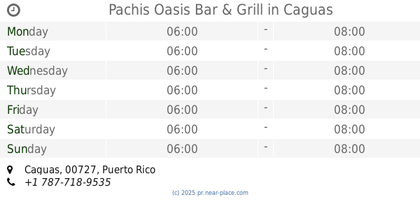
Cedrito, Comerío 00782, Puerto Rico
contacts phone
:
+1-787
Latitude:
18.2481879
, Longitude:
-66.1969701
larger map & directions
read more
nearest Bar
920 m
Noa's Cravings
Puerto Rico 167, Comerío
Bar
read more
1.768 km
El Gustazo Food & Drinks
K.m. 36.6 Bo. Naranjo, Puerto Rico 156, Comerío
Bar
read more
1.868 km
Yankee sport bar
Puerto Rico 7790, Comerío
Bar
read more
2.579 km
Barrita La Colina
Bar
read more
3.459 km
Bar Wiso Cotto
Calle Casilla Rivera, Bayamón
Bar
read more
3.983 km
Cidra Liquor Store
173 Carr 790, Cidra
Bar
read more
4.354 km
El Nuevo Quijote Bar & Grill
816 km, 1 Carretera 840, Bayamón
Bar
read more
4.457 km
Añejo Barra y Cocina
00782
Bar
read more
4.46 km
Atabey Bar and Grill
Calle Santiago R. Palmer, Comerío
Bar
read more
4.811 km
La Parada Sports Bar
km 2.5, PR-813
Bar
read more
4.827 km
Bar El Sabrosito
PR-779, Comerío
Bar
read more
4.925 km
La Mina Encontrada
PR-7774, Comerío
Bar
read more
7.287 km
La Casita De Hiram
Bar
read more
12.197 km
Nuevo Bosque
PR-165 Corozal, Toa Alta
Bar
read more
13.304 km
Colmado Santiago Guaynabo
837 Puerto Rico 837, Guaynabo
Bar
read more
13.692 km
Pachis Oasis Bar & Grill
Caguas
Bar
read more
13.932 km
El Veterano Sports Bar & Grill
Carretera 861, Toa Alta
Bar
read more
14.031 km
El Viejo Saez
200-204 Calle 1, Bayamón
Bar
read more
14.035 km
El Laurel
Puerto Rico 169, Guaynabo
Bar
read more
14.892 km
El Nuevo Jibarito
Bar
read more
15.166 km
Metropol Restaurant - Guaynabo
Avenida Las Cumbres
Bar
Restaurant
Food
Point of interest
Establishment
read more
15.39 km
La Cabaña
Carretera 798 Intersección, Puerto Rico 1, Caguas
Restaurant
Bar
Food
Point of interest
Establishment
read more
16.033 km
The New Riverside Bar
Caguas
Bar
read more
16.319 km
Cafe Lola
24 Calle Gańdara, Corozal
Bar
read more
19.289 km
La Bodeguita De Pedro
1761 Avenida Paraná, San Juan
Bar
read more
📑
all categories
Accounting
Administrative area level 1
Administrative area level 2
Airport
Amusement park
Aquarium
Art gallery
Atm
Bakery
Bank
Bar
Beauty salon
Bicycle store
Book store
Bowling alley
Bus station
Cafe
Campground
Car dealer
Car rental
Car repair
Car wash
Casino
Cemetery
Church
City hall
Clothing store
Colloquial area
Convenience store
Country
Courthouse
Dentist
Department store
Doctor
Electrician
Electronics store
Embassy
Establishment
Finance
Fire station
Florist
Food
Funeral home
Furniture store
Gas station
General contractor
Grocery or supermarket
Gym
Hair care
Hardware store
Health
Hindu Temple
Home goods store
Hospital
Insurance agency
Jewelry store
Laundry
Lawyer
Library
Liquor store
Local government office
Locality
Locksmith
Lodging
Meal delivery
Meal takeaway
Mosque
Movie rental
Movie theater
Moving company
Museum
Natural feature
Neighborhood
Night club
Painter
Park
Parking
Pet store
Pharmacy
Physiotherapist
Place of worship
Plumber
Point of interest
Police
Political
Post office
Premise
Real estate agency
Restaurant
Roofing contractor
Route
Rv park, camping
School
Shoe store
Shopping mall
Spa
Stadium
Storage
Store
Subpremise
Supermarket
Synagogue
Taxi stand
Train station
Transit station
Travel agency
University
Veterinary care
Zoo
sublocality level 1
↑