Cafe nearby El Nuevo Expreso
Puerto Rico
Cafe nearby El Nuevo Expreso
El Nuevo Expreso
Carretera 839, 00959, Bayamón, PR Puerto Rico
contacts phone
:
+1 787-778-5469
Latitude:
18.3804502
, Longitude:
-66.1737378
larger map & directions
read more
nearest Cafe
838 m
Extension La Milagrosa
Calle 12, Bayamón
Cafe
read more
970 m
Aptitud Total El Club
marginal forest hill, Puerto Rico 167, Bayamón
Cafe
read more
1.33 km
Panaderia La Ruca
Condominio Riverside Plaza, 71 Calle Santa Cruz, Bayamón
Cafe
read more
1.496 km
Panaderia Castilla
Bayamón
Cafe
read more
1.541 km
Dreams CLUB
Bayamón
Cafe
read more
1.646 km
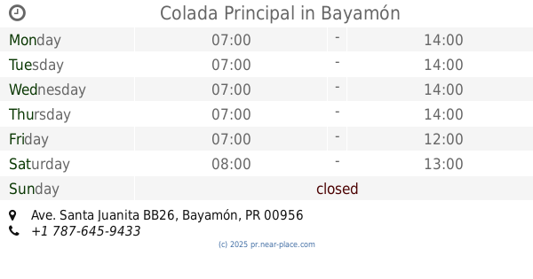
Colada Principal
Ave. Santa Juanita BB26, Bayamón
Cafe
read more
1.699 km
Panaderia La Plata
173 Carretera 839, Bayamón
Cafe
read more
1.737 km
Gol Café
Cll India, Soccer Complex 1,, Bayamón
Cafe
read more
1.77 km
Villa Cafe
Puerto Rico, Calle Comerio, Bayamón
Cafe
read more
1.872 km
Dulce Aroma’s Café
Avenida Nogal, Bayamón
Cafe
read more
1.873 km
Dulce Aroma’s Café
Avenida Nogal, 4X6
Cafe
read more
1.873 km
Dulce Aromas's Cafe
Avenida Nogal, 4X6
Cafe
read more
1.88 km
Fresh And Fancy Bakery
Bayamón
Cafe
read more
1.894 km
Wow Coffe Shop
Bayamón
Cafe
read more
1.969 km
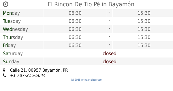
El Rincon De Tio Pé
Calle 21, Bayamón
Cafe
read more
2.029 km
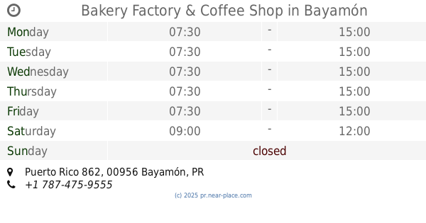
Bakery Factory & Coffee Shop
Puerto Rico 862, Bayamón
Cafe
read more
2.031 km
Donde Quieras... Café!
J-15 Ext. Hnas., Calle 2, Bayamón
Cafe
read more
2.06 km
Latino Coffee Shop
Calle 14 #U-1, Flamboyan Gardens, Bayamón
Cafe
read more
2.178 km
W HOT DOG
Calle 8, Bayamón
Cafe
read more
2.18 km
The Koffe Café
Bayamón
Cafe
read more
2.23 km
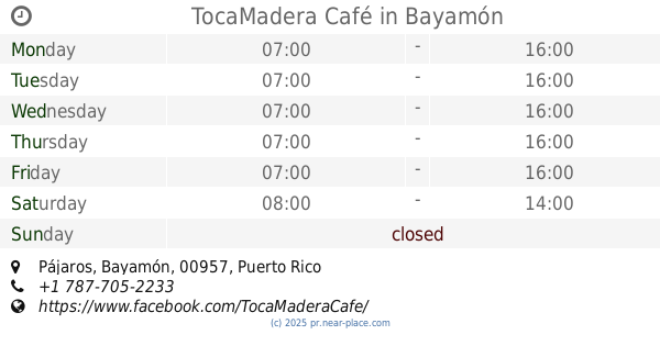
TocaMadera Café
Bayamón
Cafe
read more
2.423 km
Hacienda Carrión Café de Altura
100 Bosque Sereno, Apt 167, Bayamón
Cafe
read more
2.485 km
Tazza Coffehouse
Carr. 167 Plaza El Mercado #9, Bayamón
Cafe
read more
2.49 km
Hacienda Carrión Café de Altura
Urb. Rexville BB18 Calle, 38 Avenida Las Cumbres, Bayamón
Cafe
Restaurant
Food
Point of interest
Establishment
read more
2.737 km
ACAI & COFFEE SHOP
17 Calle Maceo, Bayamón
Cafe
read more
📑
all categories
Accounting
Administrative area level 1
Administrative area level 2
Airport
Amusement park
Aquarium
Art gallery
Atm
Bakery
Bank
Bar
Beauty salon
Bicycle store
Book store
Bowling alley
Bus station
Cafe
Campground
Car dealer
Car rental
Car repair
Car wash
Casino
Cemetery
Church
City hall
Clothing store
Colloquial area
Convenience store
Country
Courthouse
Dentist
Department store
Doctor
Electrician
Electronics store
Embassy
Establishment
Finance
Fire station
Florist
Food
Funeral home
Furniture store
Gas station
General contractor
Grocery or supermarket
Gym
Hair care
Hardware store
Health
Hindu Temple
Home goods store
Hospital
Insurance agency
Jewelry store
Laundry
Lawyer
Library
Liquor store
Local government office
Locality
Locksmith
Lodging
Meal delivery
Meal takeaway
Mosque
Movie rental
Movie theater
Moving company
Museum
Natural feature
Neighborhood
Night club
Painter
Park
Parking
Pet store
Pharmacy
Physiotherapist
Place of worship
Plumber
Point of interest
Police
Political
Post office
Premise
Real estate agency
Restaurant
Roofing contractor
Route
Rv park, camping
School
Shoe store
Shopping mall
Spa
Stadium
Storage
Store
Subpremise
Supermarket
Synagogue
Taxi stand
Train station
Transit station
Travel agency
University
Veterinary care
Zoo
sublocality level 1
↑