Cafe nearby Marielys Cafe
Puerto Rico
Cafe nearby Marielys Cafe
Marielys Cafe
57, Calle A, 00698, Yauco, PR Puerto Rico
contacts phone
:
+1 787-507-5370
Latitude:
18.0134186
, Longitude:
-66.8711132
larger map & directions
read more
nearest Cafe
933 m
Yauco Bakery
Puerto Rico 121, Yauco
Cafe
read more
2.342 km
El Meson Sandwiches (Yauco Plaza)
Yauco Plaza Mall, PR-2 Int. 128 Bo, Yauco
Cafe
read more
2.569 km
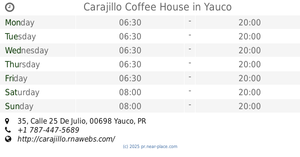
Carajillo Coffee House
35 Calle 25 De Julio, Yauco
Cafe
read more
2.723 km
Cafe Don Rey
Yauco
Cafe
read more
2.778 km
Donut World
Yauco
Cafe
read more
2.797 km
El Flamboyan II
Yauco
Cafe
read more
2.958 km
El Pio Pio
68 Calle 25 De Julio, Yauco
Cafe
read more
3.009 km
Belgica's Bakery
00653
Cafe
read more
3.068 km
El Café de Marta
10, 2 Calle Pacheco, Yauco
Cafe
read more
3.139 km
Cafeteria El Flamboyan
Calle Baldorioty, Yauco
Cafe
read more
3.24 km
Gino's Cafe
Calle Comercio, Yauco
Cafe
read more
3.282 km
Dolche Salao
Puerto Rico
Cafe
read more
3.298 km
Cafeteria Estampas De Borinquen
2-16 Avenida Santiago Vivaldi, Yauco
Cafe
read more
3.363 km
Cafeteria La Barca
28 (frente a AAA), Calle 25 De Julio, Yauco
Cafe
read more
3.398 km
Cafeito
34-48 Calle Mattei Lluveras, Yauco
Cafe
read more
3.61 km
Rosa's Café
2 Calle 25 De Julio, Yauco
Cafe
read more
3.625 km
Ecuajey Food
Calle A, Guanica
Cafe
read more
4.038 km
Panaderia Mana
PR-121, Guanica, Sabana Grande
Cafe
read more
7.685 km
El Gustazo De Chuke.
Puerto Rico 127, Guayanilla
Cafe
read more
8.425 km
Café Montalvo
Guayanilla
Cafe
read more
18.982 km
Hilario's Cakes
San Germán
Cafe
read more
20.489 km
Plazas Cafe
San Germán
Cafe
read more
23.743 km
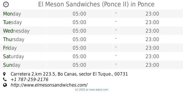
El Meson Sandwiches (Ponce II)
Carretera 2,km 223.5, Bo Canas, sector El Tuque., Ponce
Cafe
read more
26.848 km
Constancia Bakery
Hormigueros
Cafe
read more
27.552 km
Dame K-fe
Cafe
read more
📑
all categories
Accounting
Administrative area level 1
Administrative area level 2
Airport
Amusement park
Aquarium
Art gallery
Atm
Bakery
Bank
Bar
Beauty salon
Bicycle store
Book store
Bowling alley
Bus station
Cafe
Campground
Car dealer
Car rental
Car repair
Car wash
Casino
Cemetery
Church
City hall
Clothing store
Colloquial area
Convenience store
Country
Courthouse
Dentist
Department store
Doctor
Electrician
Electronics store
Embassy
Establishment
Finance
Fire station
Florist
Food
Funeral home
Furniture store
Gas station
General contractor
Grocery or supermarket
Gym
Hair care
Hardware store
Health
Hindu Temple
Home goods store
Hospital
Insurance agency
Jewelry store
Laundry
Lawyer
Library
Liquor store
Local government office
Locality
Locksmith
Lodging
Meal delivery
Meal takeaway
Mosque
Movie rental
Movie theater
Moving company
Museum
Natural feature
Neighborhood
Night club
Painter
Park
Parking
Pet store
Pharmacy
Physiotherapist
Place of worship
Plumber
Point of interest
Police
Political
Post office
Premise
Real estate agency
Restaurant
Roofing contractor
Route
Rv park, camping
School
Shoe store
Shopping mall
Spa
Stadium
Storage
Store
Subpremise
Supermarket
Synagogue
Taxi stand
Train station
Transit station
Travel agency
University
Veterinary care
Zoo
sublocality level 1
↑