Cafe nearby PICATTA CAFÉ
Puerto Rico
Cafe nearby PICATTA CAFÉ
PICATTA CAFÉ
Avenida laurel 2A 19, Bayamón Puerto Rico
contacts phone
:
+1-787
Latitude:
18.3362865
, Longitude:
-66.152716
read more
nearest Cafe
1.567 km
Shainy Dog
Puerto Rico 830, Bayamón
Cafe
read more
1.998 km
Doña Juana Café
PR-833, Bayamón, Guaynabo
Cafe
read more
2.131 km
Cafeteria La Primera Ayuda
Puerto Rico 837, Santa Rosa
Cafe
read more
2.399 km
Panadería y Repostería Cerro Gordo
Bayamón
Cafe
read more
2.452 km
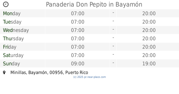
Panaderia Don Pepito
Bayamón
Cafe
read more
2.534 km
POLAKO
Avenida Hostos, Bayamón
Cafe
read more
2.904 km
Rey's Tripletas
Puerto Rico 831, Bayamón
Cafe
read more
3.064 km
Jesus's Coffee Shop
Avenida Santa Juanita, Bayamón
Cafe
read more
3.119 km
Delicias Bakery and Bistro
Carretera 837 km 0.6 Bo, Guaynabo
Cafe
Meal delivery
Bakery
Restaurant
Food
Point of interest
Store
Establishment
read more
3.51 km
Café 20/20
Cafe
read more
3.584 km
Wow Coffe Shop
Bayamón
Cafe
read more
4.614 km
Extension La Milagrosa
Calle 12, Bayamón
Cafe
read more
4.635 km
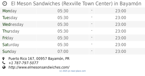
El Meson Sandwiches (Rexville Town Center)
Puerto Rico 167, Bayamón
Cafe
read more
4.657 km
Alex Grill
Calle Del Rio, Guaynabo
Cafe
read more
4.752 km
El Picoteo BBQ
Bayamón
Cafe
read more
4.799 km
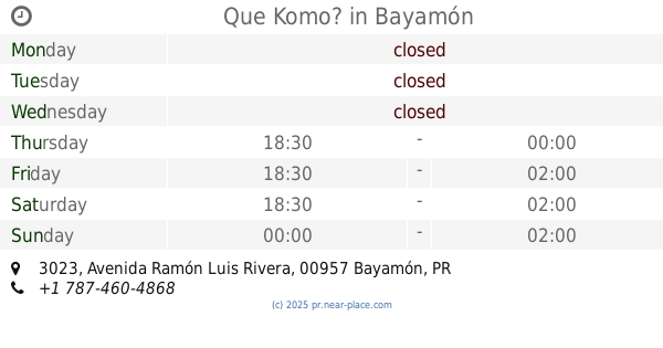
Que Komo?
3023 Avenida Ramón Luis Rivera, Bayamón
Cafe
read more
4.817 km
Rest Good Fortune
11-23 Calle Baldorioty, Guaynabo
Cafe
read more
4.949 km
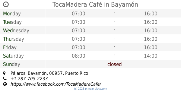
TocaMadera Café
Bayamón
Cafe
read more
4.988 km
Crash N Smash
86 Calle Carazo, Guaynabo, Esq. Luis Muñoz Rivera, Guaynabo
Cafe
read more
4.992 km
Dulce Aromas's Cafe
Avenida Nogal, 4X6
Cafe
read more
5.008 km
Los Juanes Cafe
11 George L. Colton Street, Guaynabo
Cafe
read more
5.029 km
Café Lab by Latte que Latte
Avenida Parque de los Niños, Guaynabo
Cafe
read more
5.032 km
Cafeteria Mi Pueblo
16 Herminio Díaz Navarro Street, Guaynabo
Cafe
read more
5.544 km
BAYAMON TOBACCO CORP
167 Km. 11.8 Bo. Dajaos, Bayamón
Cafe
read more
5.898 km
Delicadas
Bayamón
Cafe
read more
📑
all categories
Accounting
Administrative area level 1
Administrative area level 2
Airport
Amusement park
Aquarium
Art gallery
Atm
Bakery
Bank
Bar
Beauty salon
Bicycle store
Book store
Bowling alley
Bus station
Cafe
Campground
Car dealer
Car rental
Car repair
Car wash
Casino
Cemetery
Church
City hall
Clothing store
Colloquial area
Convenience store
Country
Courthouse
Dentist
Department store
Doctor
Electrician
Electronics store
Embassy
Establishment
Finance
Fire station
Florist
Food
Funeral home
Furniture store
Gas station
General contractor
Grocery or supermarket
Gym
Hair care
Hardware store
Health
Hindu Temple
Home goods store
Hospital
Insurance agency
Jewelry store
Laundry
Lawyer
Library
Liquor store
Local government office
Locality
Locksmith
Lodging
Meal delivery
Meal takeaway
Mosque
Movie rental
Movie theater
Moving company
Museum
Natural feature
Neighborhood
Night club
Painter
Park
Parking
Pet store
Pharmacy
Physiotherapist
Place of worship
Plumber
Point of interest
Police
Political
Post office
Premise
Real estate agency
Restaurant
Roofing contractor
Route
Rv park, camping
School
Shoe store
Shopping mall
Spa
Stadium
Storage
Store
Subpremise
Supermarket
Synagogue
Taxi stand
Train station
Transit station
Travel agency
University
Veterinary care
Zoo
sublocality level 1
↑