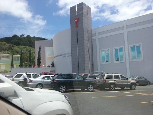
Church nearby Divino Niño de Jesus
Puerto Rico
Church nearby Divino Niño de Jesus
Divino Niño de Jesus
Calle Principal, Guaynabo Puerto Rico
contacts phone
:
+1-787
Latitude:
18.3023509
, Longitude:
-66.087856
read more
nearest Church
653 m
Misionario Evangélico
Church
read more
950 m
Buen Pastor
Church
read more
959 m
Centro Buen Pastor
KM 24 KM 24
Church
Place of worship
Point of interest
Establishment
read more
1.185 km
IGLESIA CRISTIANA PRIMICIAS DE AMOR Y FE
Km 23., 9 Calle 1, Guaynabo
Church
read more
1.282 km
NAMB Send Relief Mobilization Center
Puerto Rico 1, San Juan
Church
read more
1.345 km
Iglesia Evangelica El Faro
Church
read more
1.369 km
Iglesia Faro De Bendición
Church
read more
1.591 km
Iglesia Cristiana Primicias de Amor y Fe
Church
read more
1.73 km
Iglesia Cristiana Discipulos de Cristo Hato Nuevo Guaynabo PR
Antigua PR-834
Church
read more
1.819 km
Iglesia San José
Church
read more
1.819 km
IDDPMI Las Lomas
Unnamed Road, San Juan
Church
read more
2.061 km
Iglesia Casa de Bendición
Rio, Guaynabo
Church
read more
2.073 km
Iglesia Catedral De La Fe
Carretera Felipe la Voz Rodriguez, Caguas
Church
read more
2.075 km
Catedral de la Fe
18°18'10.2"N 66°03'56.0"W
Church
read more
2.138 km
Iglesia De Dios Misionera Oasis De Bendicion
Camino Los Colones, San Juan
Church
read more
2.507 km
Capilla San Juan Bosco, Mamey I, Guaynabo
Church
read more
2.725 km
Iglesia La Changa MMM
Puerto Rico 799, Caguas
Church
read more
2.854 km
Iglesia Metodista Jehová Adonai
Church
read more
2.965 km
Iglesia Restauracion Refugio Celestial
Puerto Rico 842, San Juan
Church
read more
3.04 km
Parroquia Santa Catalina Laboure
Caimito
Church
read more
3.049 km
Iglesia de Cristo Misionera, Los Pérez
Caimito
Church
read more
3.058 km
Iglesia de Cristo Misionera
Caimito
Church
read more
3.068 km
Iglesia Sagrado Corazón
Church
read more
3.248 km
Pote De Sal
Carr 835 Km 2.2 Mamey I, Guaynabo
Church
read more
3.255 km
Iglesia Fuente De Agua Viva Guaynabo
PR 835 2.2 Mamey I, Guaynabo
Church
read more
📑
all categories
Accounting
Administrative area level 1
Administrative area level 2
Airport
Amusement park
Aquarium
Art gallery
Atm
Bakery
Bank
Bar
Beauty salon
Bicycle store
Book store
Bowling alley
Bus station
Cafe
Campground
Car dealer
Car rental
Car repair
Car wash
Casino
Cemetery
Church
City hall
Clothing store
Colloquial area
Convenience store
Country
Courthouse
Dentist
Department store
Doctor
Electrician
Electronics store
Embassy
Establishment
Finance
Fire station
Florist
Food
Funeral home
Furniture store
Gas station
General contractor
Grocery or supermarket
Gym
Hair care
Hardware store
Health
Hindu Temple
Home goods store
Hospital
Insurance agency
Jewelry store
Laundry
Lawyer
Library
Liquor store
Local government office
Locality
Locksmith
Lodging
Meal delivery
Meal takeaway
Mosque
Movie rental
Movie theater
Moving company
Museum
Natural feature
Neighborhood
Night club
Painter
Park
Parking
Pet store
Pharmacy
Physiotherapist
Place of worship
Plumber
Point of interest
Police
Political
Post office
Premise
Real estate agency
Restaurant
Roofing contractor
Route
Rv park, camping
School
Shoe store
Shopping mall
Spa
Stadium
Storage
Store
Subpremise
Supermarket
Synagogue
Taxi stand
Train station
Transit station
Travel agency
University
Veterinary care
Zoo
sublocality level 1
↑