Gas station nearby Total Barrio Palmas
Puerto Rico
Gas station nearby Total Barrio Palmas
Total Barrio Palmas
Carr. 779 Km. 8.8, Bo. Paloma, Comerio Puerto Rico
contacts phone
:
+1-787
Latitude:
18.230937
, Longitude:
-66.255562
read more
nearest Gas station
TOTAL Tankstelle
Carr. 779 Km. 8.8, Bo. Paloma, Comerio
Gas station
read more
1.562 km
JJ Service Station & Race Bar
Palomas
Gas station
read more
2.934 km
Puma Gas Station 336
Puerto Rico 152
Gas station
read more
2.934 km
Puma Gas Station
Puerto Rico 152
Gas station
read more
2.935 km
Oasis Service Station (Puma)
Puerto Rico 152, Comerío
Gas station
read more
3.023 km
Mega Gas Station
PR-878
Gas station
read more
3.051 km
Puma Super Station #2
Gas station
read more
3.051 km
Anones Service Station
Gas station
read more
3.548 km
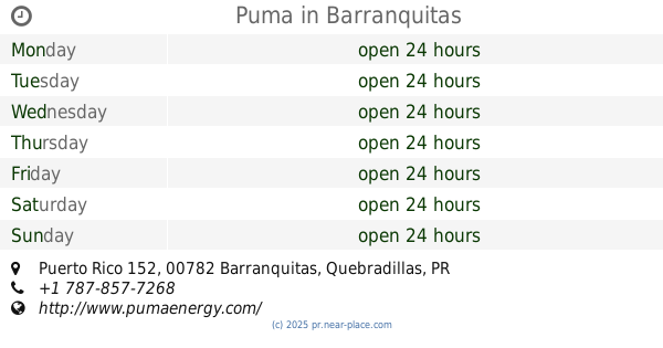
Puma
Puerto Rico 152, Barranquitas
Gas station
read more
3.64 km
Gasolinera To Go Stores
Piñas
Gas station
read more
4.311 km
Ecomaxx Naranjito
Gas station
read more
5.582 km
Gulf Torres Casanova
Puerto Rico 152, Barranquitas
Gas station
read more
9.096 km
TOTAL Tankstelle
Helechal
Gas station
read more
9.192 km
Gasolinera Los Robles
Robles
Gas station
read more
10.892 km
Puma Gas Station
Carr 167, Bayamón
Gas station
read more
11.51 km
Garaje Puma Cidra
Gas station
read more
11.88 km
Puma
68 Calle Antonio R. Barcelo, Cidra
Gas station
read more
12.12 km
San Antonio Shell # 3
PR-7733, Cidra
Gas station
read more
12.628 km
Ecomaxx Panoramic S/S
Puerto Rico 722, Aibonito
Gas station
read more
13.411 km
Puma
Puerto Rico 173, Aguas Buenas
Gas station
read more
14.329 km
Shell
Calle Ramos Antonini, Orocovis
Gas station
read more
15.225 km
Eureka
Puerto Rico 174, Aguas Buenas
Gas station
read more
15.234 km
Shell
Carretera 861, Toa Alta
Gas station
read more
16.34 km
Margaro Gas Fluido
Avenida Campo Bello
Gas station
read more
16.929 km
Minillas Gulf
Avenida Minillas, Bayamón
Gas station
Point of interest
Establishment
read more
📑
all categories
Accounting
Administrative area level 1
Administrative area level 2
Airport
Amusement park
Aquarium
Art gallery
Atm
Bakery
Bank
Bar
Beauty salon
Bicycle store
Book store
Bowling alley
Bus station
Cafe
Campground
Car dealer
Car rental
Car repair
Car wash
Casino
Cemetery
Church
City hall
Clothing store
Colloquial area
Convenience store
Country
Courthouse
Dentist
Department store
Doctor
Electrician
Electronics store
Embassy
Establishment
Finance
Fire station
Florist
Food
Funeral home
Furniture store
Gas station
General contractor
Grocery or supermarket
Gym
Hair care
Hardware store
Health
Hindu Temple
Home goods store
Hospital
Insurance agency
Jewelry store
Laundry
Lawyer
Library
Liquor store
Local government office
Locality
Locksmith
Lodging
Meal delivery
Meal takeaway
Mosque
Movie rental
Movie theater
Moving company
Museum
Natural feature
Neighborhood
Night club
Painter
Park
Parking
Pet store
Pharmacy
Physiotherapist
Place of worship
Plumber
Point of interest
Police
Political
Post office
Premise
Real estate agency
Restaurant
Roofing contractor
Route
Rv park, camping
School
Shoe store
Shopping mall
Spa
Stadium
Storage
Store
Subpremise
Supermarket
Synagogue
Taxi stand
Train station
Transit station
Travel agency
University
Veterinary care
Zoo
sublocality level 1
↑