Restaurant nearby Andrea's Sweetness
Puerto Rico
Restaurant nearby Andrea's Sweetness
Andrea's Sweetness
Puerto Rico 510, Mercedita Puerto Rico
contacts phone
:
+1-787
Latitude:
18.0108995
, Longitude:
-66.5328052
read more
nearest Restaurant
992 m
El Palacio Chino
Capitanejo
Restaurant
read more
1.755 km
Villa Caollo
Capitanejo
Restaurant
read more
2.697 km
Letrero de Pare
Puerto Rico, Juana Díaz
Restaurant
read more
3.354 km
Burger King
Puerto Rico 506, Coto Laurel
Restaurant
read more
3.391 km
SUBWAY®Restaurants
Coto Laurel Ward, Space CLP-1, Coto Laurel Plaza, Ponce
Restaurant
read more
3.391 km
Subway Restaurants
Coto Laurel Ward, Space CLP-1, Coto Laurel Plaza, Ponce
Restaurant
read more
3.391 km
Subway
Coto Laurel Ward, Space CLP-1, Coto Laurel Plaza, Ponce
Restaurant
read more
3.394 km
The Taco Maker
Puerto Rico 506, Coto Laurel
Restaurant
read more
3.403 km
Church's Chicken
Coto Laurel Plaza 506 Int Carr, Puerto Rico 52, Ponce
Restaurant
read more
3.406 km
Pollo Tropical
Puerto Rico 506, Coto Laurel
Restaurant
read more
3.557 km
La Casa de la Rumba
Barrio La Calzada Carr #1, Ponce
Restaurant
read more
3.84 km
Magayan Patio
Puerto Rico 149, Juana Díaz
Restaurant
read more
3.883 km
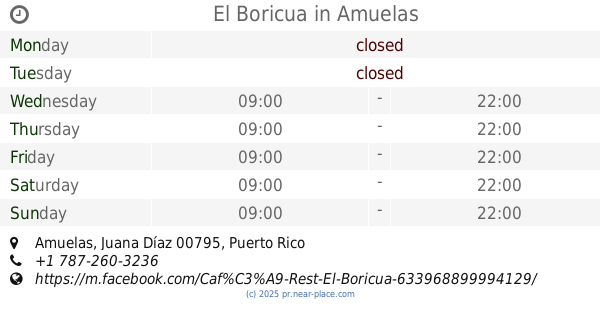
El Boricua
Amuelas
Restaurant
read more
4.496 km
El Turpial Boricua
Calle Jose de Diego Buzón #35, Coto Laurel
Restaurant
read more
4.528 km
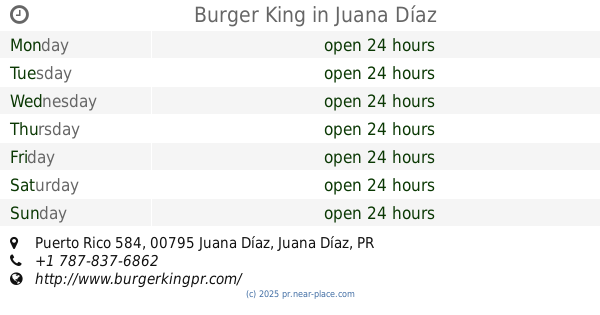
Burger King
Puerto Rico 584, Juana Díaz
Restaurant
read more
4.734 km
La Borinqueña
Puerto Rico 14, Juana Díaz
Restaurant
read more
5.034 km
Paseo La Puchita
Calle Cerrillos, Coto Laurel
Restaurant
read more
5.063 km
Hacienda Real
Restaurant
read more
5.07 km
LA GORDITA RELLENA
Calle 14, Juana Díaz
Restaurant
read more
5.08 km
Ceviche D' Aqui
2507, Carr 14, Coto Laurel
Restaurant
read more
5.793 km
El Negocio de Panchi
Ponce
Restaurant
read more
5.848 km
Sazón
Ponce
Restaurant
read more
5.866 km
Taco Bell
Avenida Tito Castro, Ponce
Restaurant
read more
6.009 km
McDonald's
Ponce
Restaurant
read more
6.045 km
China Star
14 cotto laurel carretera, Ponce
Restaurant
read more
📑
all categories
Accounting
Administrative area level 1
Administrative area level 2
Airport
Amusement park
Aquarium
Art gallery
Atm
Bakery
Bank
Bar
Beauty salon
Bicycle store
Book store
Bowling alley
Bus station
Cafe
Campground
Car dealer
Car rental
Car repair
Car wash
Casino
Cemetery
Church
City hall
Clothing store
Colloquial area
Convenience store
Country
Courthouse
Dentist
Department store
Doctor
Electrician
Electronics store
Embassy
Establishment
Finance
Fire station
Florist
Food
Funeral home
Furniture store
Gas station
General contractor
Grocery or supermarket
Gym
Hair care
Hardware store
Health
Hindu Temple
Home goods store
Hospital
Insurance agency
Jewelry store
Laundry
Lawyer
Library
Liquor store
Local government office
Locality
Locksmith
Lodging
Meal delivery
Meal takeaway
Mosque
Movie rental
Movie theater
Moving company
Museum
Natural feature
Neighborhood
Night club
Painter
Park
Parking
Pet store
Pharmacy
Physiotherapist
Place of worship
Plumber
Point of interest
Police
Political
Post office
Premise
Real estate agency
Restaurant
Roofing contractor
Route
Rv park, camping
School
Shoe store
Shopping mall
Spa
Stadium
Storage
Store
Subpremise
Supermarket
Synagogue
Taxi stand
Train station
Transit station
Travel agency
University
Veterinary care
Zoo
sublocality level 1
↑