Restaurant nearby Antojito Salinas
Puerto Rico
Restaurant nearby Antojito Salinas
Antojito Salinas
Toíta, Cayey Puerto Rico
contacts phone
:
+1-787
Latitude:
18.1351856
, Longitude:
-66.1944046
read more
nearest Restaurant
252 m
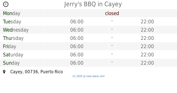
Jerry's BBQ
Cayey
Restaurant
read more
2.467 km
Naldo's Pizza
Cayey
Restaurant
read more
2.775 km
Junior Pizza
Restaurant
read more
2.995 km
Friquitin El Chévere
Avenida José De Diego, Cayey
Restaurant
read more
3.144 km
Villa Rosa
Parcelas Nuevas
Restaurant
read more
3.454 km
La Nueva Sándwichera
José de Diego Road (Entrada al Parque Pedro Montañez, Cayey
Restaurant
read more
3.535 km
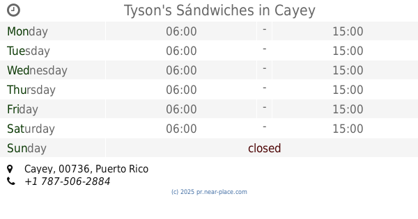
Tyson's Sándwiches
Cayey
Restaurant
read more
3.577 km
Filipo's Pizza
Cayey
Restaurant
read more
3.582 km
Fillipo's Pizza
Calle Nuñez Romeu, Cayey
Restaurant
read more
3.727 km
El Mangotin del Gordo
1-31 Calle Baldorioty de Castro, Cayey
Restaurant
read more
3.749 km
TeAngels Cayey
Calle Sánchez Sur 114, Urb. Aponte, Cayey, PR 00736
Restaurant
read more
3.805 km
Friquitin El Chévere
Avenida Jose de Diego Esquina Muñoz
Restaurant
read more
3.829 km
El Rincón Tropical
Puerto Rico 171, Cayey
Restaurant
read more
3.858 km
La Pizzeria Plaza
60 Calle Luis Muñoz Rivera, Cayey
Restaurant
read more
3.933 km
Cafeteria Sbores Doña Tina
125, 101 Calle Luis Muñoz Rivera, Cayey
Restaurant
read more
3.941 km
Peace n' Loaf Cayey
Cayey
Restaurant
read more
4.055 km
El Carrito Del Sabor
Calle 14, Cayey
Restaurant
read more
4.077 km
Amazing Pretzel
Calle Antonio R. Barceló, Cayey
Restaurant
read more
4.613 km
La Hamberguera
Cayey
Restaurant
read more
4.822 km
KFC
Avenida Luis Muñoz Marín, Cayey
Restaurant
read more
4.881 km
Burger King
Puerto Rico 1, Cayey
Restaurant
read more
5.229 km
El Gastro Spot: Late Nite
Calle Los Robles, Cayey
Restaurant
read more
5.998 km
El Yukery
Restaurant
read more
6.205 km
Hacienda Mi Remanso
Puerto Rico 172, Cidra
Restaurant
read more
6.22 km
Church's Chicken
88 Calle Antonio R. Barcelo, Cidra
Restaurant
read more
📑
all categories
Accounting
Administrative area level 1
Administrative area level 2
Airport
Amusement park
Aquarium
Art gallery
Atm
Bakery
Bank
Bar
Beauty salon
Bicycle store
Book store
Bowling alley
Bus station
Cafe
Campground
Car dealer
Car rental
Car repair
Car wash
Casino
Cemetery
Church
City hall
Clothing store
Colloquial area
Convenience store
Country
Courthouse
Dentist
Department store
Doctor
Electrician
Electronics store
Embassy
Establishment
Finance
Fire station
Florist
Food
Funeral home
Furniture store
Gas station
General contractor
Grocery or supermarket
Gym
Hair care
Hardware store
Health
Hindu Temple
Home goods store
Hospital
Insurance agency
Jewelry store
Laundry
Lawyer
Library
Liquor store
Local government office
Locality
Locksmith
Lodging
Meal delivery
Meal takeaway
Mosque
Movie rental
Movie theater
Moving company
Museum
Natural feature
Neighborhood
Night club
Painter
Park
Parking
Pet store
Pharmacy
Physiotherapist
Place of worship
Plumber
Point of interest
Police
Political
Post office
Premise
Real estate agency
Restaurant
Roofing contractor
Route
Rv park, camping
School
Shoe store
Shopping mall
Spa
Stadium
Storage
Store
Subpremise
Supermarket
Synagogue
Taxi stand
Train station
Transit station
Travel agency
University
Veterinary care
Zoo
sublocality level 1
↑