Restaurant nearby El fogon
Puerto Rico
Restaurant nearby El fogon
El fogon
contacts phone
:
+1-787
Latitude:
18.321827
, Longitude:
-66.1866969
read more
nearest Restaurant
775 m
La Casita De Carmen
Sec Los Brahas, Bayamón
Restaurant
read more
973 m
Pizza Italiah
00957
Restaurant
read more
1.101 km
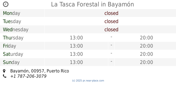
La Tasca Forestal
Bayamón
Restaurant
read more
1.939 km
Brisas Del Lago
3007 Carr 167, Bayamón
Restaurant
read more
2.005 km
Lechonera Papo Nieves
Avenida Ramón Luis Rivera, Bayamón
Restaurant
read more
2.049 km
Los Checos
3007 Carretera 828, Bayamón
Restaurant
read more
2.049 km
Los Checos
3007 Carr 167, Bayamón
Restaurant
read more
2.468 km
La Frontera, Alcapurias y Almuerzos
Puerto Rico 830, Bayamón
Restaurant
read more
2.51 km
Subway
Road #167 Esq. 6A, Van Scoy, Gasolinera Total, Bayamón
Restaurant
read more
2.545 km
El Gran Bambuin
Restaurant
read more
2.569 km
El Hp Burguer
Restaurant
read more
2.584 km
Firehouse Subs
Restaurant
read more
2.607 km
Palacio City
1900, 1900 Carretera 167, Bayamón
Restaurant
read more
2.67 km
Wendy's
Restaurant
read more
2.708 km
Mimi's BBQ
Puerto Rico 167, Bayamón
Restaurant
read more
2.751 km
Pizza Like Heaven
1900 Carretera 167, Bayamón
Restaurant
read more
2.76 km
BRASADURA STEAKHOUSE
Carretera 167 Km 3.5, Bayamón
Restaurant
read more
2.763 km
Taco Fino
Los Km 4.4, Avenida Palacios de Versalles
Restaurant
read more
2.805 km
La Bolona Restaurant
carretera, 167
Restaurant
read more
2.863 km
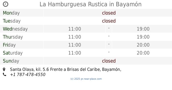
La Hamburguesa Rustica
Santa Olaya, kil. 5.6 Frente a Brisas del Caribe, Bayamón
Restaurant
read more
2.9 km
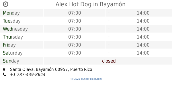
Alex Hot Dog
Restaurant
read more
2.98 km
Firehouse Subs
Puerto Rico 830, Bayamón
Restaurant
read more
2.988 km
Church's Chicken
Plaza Interamericana Carr 830 KM 0.5, Bayamon
Restaurant
read more
2.991 km
Burger King
Puerto Rico 830, Bayamón
Restaurant
read more
3.58 km
El Rincón Del Pón
Restaurant
read more
📑
all categories
Accounting
Administrative area level 1
Administrative area level 2
Airport
Amusement park
Aquarium
Art gallery
Atm
Bakery
Bank
Bar
Beauty salon
Bicycle store
Book store
Bowling alley
Bus station
Cafe
Campground
Car dealer
Car rental
Car repair
Car wash
Casino
Cemetery
Church
City hall
Clothing store
Colloquial area
Convenience store
Country
Courthouse
Dentist
Department store
Doctor
Electrician
Electronics store
Embassy
Establishment
Finance
Fire station
Florist
Food
Funeral home
Furniture store
Gas station
General contractor
Grocery or supermarket
Gym
Hair care
Hardware store
Health
Hindu Temple
Home goods store
Hospital
Insurance agency
Jewelry store
Laundry
Lawyer
Library
Liquor store
Local government office
Locality
Locksmith
Lodging
Meal delivery
Meal takeaway
Mosque
Movie rental
Movie theater
Moving company
Museum
Natural feature
Neighborhood
Night club
Painter
Park
Parking
Pet store
Pharmacy
Physiotherapist
Place of worship
Plumber
Point of interest
Police
Political
Post office
Premise
Real estate agency
Restaurant
Roofing contractor
Route
Rv park, camping
School
Shoe store
Shopping mall
Spa
Stadium
Storage
Store
Subpremise
Supermarket
Synagogue
Taxi stand
Train station
Transit station
Travel agency
University
Veterinary care
Zoo
sublocality level 1
↑