Restaurant nearby Neo's
Puerto Rico
Restaurant nearby Neo's
Neo's
Calle Robles, San Juan Puerto Rico
contacts phone
:
+1-787
Latitude:
18.4003399
, Longitude:
-66.0461197
read more
nearest Restaurant
60 m
Cafetería Zoila
169, 165 Calle Robles, San Juan
Restaurant
read more
201 m
XFC Chicken
1071 Calle Monseñor William Jones, San Juan
Restaurant
read more
309 m
El Obrero
273 Calle Robles, San Juan
Restaurant
read more
309 m
La Cajita China
Avenida Barbosa, San Juan
Restaurant
read more
339 m
Wicked Brgr.
Calle Añasco, San Juan
Restaurant
read more
389 m
Antojito sabroso
102 Calle Arzuaga, San Juan
Restaurant
read more
576 m
La Fonda Criolla
San Juan
Restaurant
read more
601 m
Flor De Parcha
3 Calle Saldaña, San Juan
Restaurant
read more
620 m
GuaKmole
Calle José de Diego, San Juan
Restaurant
read more
638 m
Little Caesars Pizza
Ave Regimiento 65 de Infantería, Av. 65 de Infantería, San Juan
Restaurant
read more
724 m
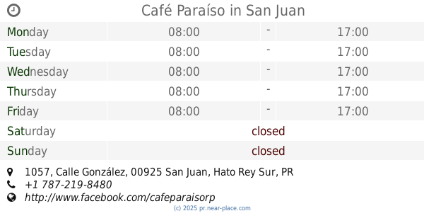
Café Paraíso
1057 Calle González, San Juan
Restaurant
read more
728 m
Burger King
Calle Amalia Marín, San Juan
Restaurant
read more
744 m
Subway
Esq Ave Barbosa, Store #1-14, 65th Infantry Shopping Center, Rio Piedras
Restaurant
read more
763 m
Corona China
San Juan
Restaurant
read more
815 m
McDonald's #117
Calle 3, San Juan
Restaurant
read more
858 m
Lechonera Guavate en Rio Piedras
Calle Brumbaugh, San Juan
Restaurant
read more
938 m
Pitanza
San Juan
Restaurant
read more
949 m
Rest Los Monkeys (Hamburgers)
103 Avenida Universidad, San Juan
Restaurant
read more
964 m
Vidy's Cafe
104 Avenida Universidad, San Juan
Restaurant
read more
985 m
Zen Sushi
107 Avenida Universidad #4, San Juan
Restaurant
read more
1.02 km
El Gallo Fried Chicken
119 Avenida Universidad, San Juan
Restaurant
read more
1.045 km
Ayala restaurant
San Juan
Restaurant
read more
1.086 km
blumberry
San Juan
Restaurant
read more
1.127 km
El Rey del Mofongo
416 Av. 65 de Infantería, San Juan
Restaurant
read more
1.146 km
VEGETARIANO VEGANO
Venezuela # 25 Guaracanal, San Juan
Restaurant
read more
📑
all categories
Accounting
Administrative area level 1
Administrative area level 2
Airport
Amusement park
Aquarium
Art gallery
Atm
Bakery
Bank
Bar
Beauty salon
Bicycle store
Book store
Bowling alley
Bus station
Cafe
Campground
Car dealer
Car rental
Car repair
Car wash
Casino
Cemetery
Church
City hall
Clothing store
Colloquial area
Convenience store
Country
Courthouse
Dentist
Department store
Doctor
Electrician
Electronics store
Embassy
Establishment
Finance
Fire station
Florist
Food
Funeral home
Furniture store
Gas station
General contractor
Grocery or supermarket
Gym
Hair care
Hardware store
Health
Hindu Temple
Home goods store
Hospital
Insurance agency
Jewelry store
Laundry
Lawyer
Library
Liquor store
Local government office
Locality
Locksmith
Lodging
Meal delivery
Meal takeaway
Mosque
Movie rental
Movie theater
Moving company
Museum
Natural feature
Neighborhood
Night club
Painter
Park
Parking
Pet store
Pharmacy
Physiotherapist
Place of worship
Plumber
Point of interest
Police
Political
Post office
Premise
Real estate agency
Restaurant
Roofing contractor
Route
Rv park, camping
School
Shoe store
Shopping mall
Spa
Stadium
Storage
Store
Subpremise
Supermarket
Synagogue
Taxi stand
Train station
Transit station
Travel agency
University
Veterinary care
Zoo
sublocality level 1
↑