Restaurant nearby Pito's Pizza
Puerto Rico
Restaurant nearby Pito's Pizza
Pito's Pizza
Naranjito Puerto Rico
contacts phone
:
+1-787
Latitude:
18.3068742
, Longitude:
-66.2580608
read more
nearest Restaurant
34 m
Javielito's Pizza & Restaurant
Achiote, Naranjito
Restaurant
read more
164 m
Hacienda Rosado Ayala
Carr. 165 km 7.1 Bo. Galateo 00953
Restaurant
read more
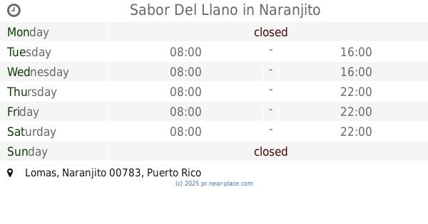
356 m
Sabor Del Llano
Restaurant
read more
752 m
Carlitos Pinchos
Naranjito
Restaurant
read more
876 m
Yan's Pizza
Naranjito
Restaurant
read more
985 m
El Trolly de Pepito
Naranjito
Restaurant
read more
1.082 km
Boricua Fried Chicken
00719, Puerto Rico 164, Naranjito
Restaurant
read more
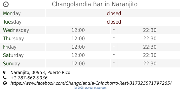
1.156 km
Changolandia Bar
Naranjito
Restaurant
read more
1.219 km
Bigger BIG
Desvio Mariano Cotto, Bayamón
Restaurant
read more
1.229 km
Almendro's Pizza & Bar
00953, Dianta Zul, Toa Alta
Restaurant
read more
1.299 km
Pueblo Adentro Bar, Café & Hamburguesa Artesanal
Naranjito
Restaurant
read more
1.369 km
Boricua Fried Chicken
94-96 Calle Georgetti, Bayamón
Restaurant
read more
1.473 km
sport pizza
s,, Naranjito
Restaurant
read more
1.478 km
J.R Burger & Grill
PR 5 Bo.Achiote el Desvío Cancha Anexa, Naranjito
Restaurant
read more
1.482 km
Monchis Express
Naranjito
Restaurant
read more
1.489 km
Checos Place
39-59 Calle I Morales Acosta, Bayamón
Restaurant
read more
1.538 km
Aponte Quick Lunch (Betsy)
Naranjito
Restaurant
read more
1.546 km
La Loganza
Puerto Rico 164, Bayamón
Restaurant
read more
1.716 km
Tazmania Munchies
Calle Desvio Naranjito, Bayamón
Restaurant
read more
1.919 km
Rancho Silvestre Lomas Naranjito
Restaurant
read more
1.961 km
Eppys Pizza
Puerto Rico 152, Corozal
Restaurant
read more
1.965 km
Eppy's Pizza
PR- PR- 00719, Puerto Rico 152
Restaurant
read more
2.104 km
Chilerican
Restaurant
read more
2.166 km
El AZ, Tu Rinconcito Chileno
Km 2.0 Bo. 00719, Puerto Rico 165, Naranjito
Restaurant
read more
2.167 km
AZ Rinconcito Chileno
Puerto Rico 165, Toa Alta
Restaurant
read more
📑
all categories
Accounting
Administrative area level 1
Administrative area level 2
Airport
Amusement park
Aquarium
Art gallery
Atm
Bakery
Bank
Bar
Beauty salon
Bicycle store
Book store
Bowling alley
Bus station
Cafe
Campground
Car dealer
Car rental
Car repair
Car wash
Casino
Cemetery
Church
City hall
Clothing store
Colloquial area
Convenience store
Country
Courthouse
Dentist
Department store
Doctor
Electrician
Electronics store
Embassy
Establishment
Finance
Fire station
Florist
Food
Funeral home
Furniture store
Gas station
General contractor
Grocery or supermarket
Gym
Hair care
Hardware store
Health
Hindu Temple
Home goods store
Hospital
Insurance agency
Jewelry store
Laundry
Lawyer
Library
Liquor store
Local government office
Locality
Locksmith
Lodging
Meal delivery
Meal takeaway
Mosque
Movie rental
Movie theater
Moving company
Museum
Natural feature
Neighborhood
Night club
Painter
Park
Parking
Pet store
Pharmacy
Physiotherapist
Place of worship
Plumber
Point of interest
Police
Political
Post office
Premise
Real estate agency
Restaurant
Roofing contractor
Route
Rv park, camping
School
Shoe store
Shopping mall
Spa
Stadium
Storage
Store
Subpremise
Supermarket
Synagogue
Taxi stand
Train station
Transit station
Travel agency
University
Veterinary care
Zoo
sublocality level 1
↑