School nearby Escuela Dr. Santos J. Sepúlveda
Puerto Rico
School nearby Escuela Dr. Santos J. Sepúlveda
Escuela Dr. Santos J. Sepúlveda
38, Calle 33, 00961, Bayamón, PR Puerto Rico
contacts phone
:
+1 787-786-7625
Latitude:
18.4036418
, Longitude:
-66.1734031
larger map & directions
read more
nearest School
387 m
Distrito Escolar de Bayamón
69 Calle 61, Bayamón
School
read more
387 m
Distrito Escolar de Bayamon,
Call I, Bayamón
School
read more
435 m
Departamento Educación Bayamón II
69 Calle 61, Bayamón
School
read more
444 m
First School Bilingue
112 Carretera Hato Tejas, Bayamón
School
read more
445 m
Escuela Especializada En Cinematografía Cacique Agueybana Secundaria
Bayamón
School
read more
456 m
Cacique Agüeybana School
69 Calle 61, Bayamón
School
read more
467 m
Escuela Ludovico Costoso
Bayamón
School
read more
548 m
SMART EDUCATION NETWORK
Calle 1, Bayamón
School
read more
589 m
Head Start La Milagrosa
Hato Tejas
School
read more
684 m
Colegio Y Cuido
Hato Tejas
School
read more
699 m
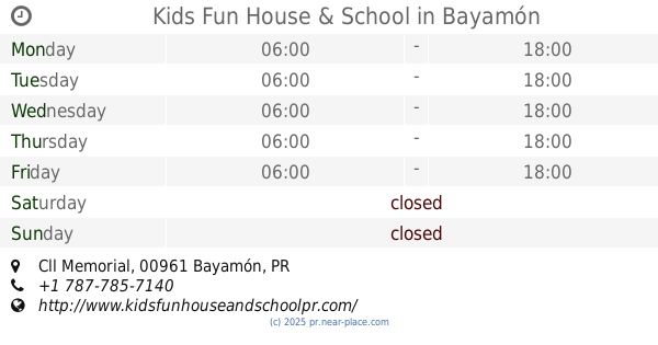
Kids Fun House & School
Cll Memorial, Bayamón
School
read more
701 m
Academia Santo Tomás de Aquino
Hato Tejas, km0.5
School
read more
722 m
Automeca
Marcador colocado cerca de, Bayamón
School
read more
766 m
Escuela Elemental Juan Morel Campos
Bayamón
School
read more
845 m
Centro Educativo Jireh
Bayamón
School
read more
956 m
Escuela José Dávila Semprit
18 Calle 21, Bayamón
School
read more
965 m
NEMA
Bayamón
School
read more
983 m
Papa Juan XXIII School
Puerto Rico, Calle Isla Nena, Bayamón
School
read more
983 m
Escuela Papa Juan XXIII
Puerto Rico, Calle Isla Nena, Bayamón
School
read more
1.034 km
Universidad Central de Bayamón
Bayamón
School
read more
1.034 km
Universidad Catãlica
Bayamón
School
read more
1.123 km
RHLA Rio Hondo Learning Academy
44 Calle 1, Bayamón
School
read more
1.158 km
Dominican Study Center of the Caribbean
27, Calle Capitan Correa, Bayamón
School
read more
1.168 km
Victory Academy
Calle H #61, Urb. Hermanas Davila, Bayamón
School
read more
1.209 km
Colegio Padres Dominicos
Bayamón
School
read more
📑
all categories
Accounting
Administrative area level 1
Administrative area level 2
Airport
Amusement park
Aquarium
Art gallery
Atm
Bakery
Bank
Bar
Beauty salon
Bicycle store
Book store
Bowling alley
Bus station
Cafe
Campground
Car dealer
Car rental
Car repair
Car wash
Casino
Cemetery
Church
City hall
Clothing store
Colloquial area
Convenience store
Country
Courthouse
Dentist
Department store
Doctor
Electrician
Electronics store
Embassy
Establishment
Finance
Fire station
Florist
Food
Funeral home
Furniture store
Gas station
General contractor
Grocery or supermarket
Gym
Hair care
Hardware store
Health
Hindu Temple
Home goods store
Hospital
Insurance agency
Jewelry store
Laundry
Lawyer
Library
Liquor store
Local government office
Locality
Locksmith
Lodging
Meal delivery
Meal takeaway
Mosque
Movie rental
Movie theater
Moving company
Museum
Natural feature
Neighborhood
Night club
Painter
Park
Parking
Pet store
Pharmacy
Physiotherapist
Place of worship
Plumber
Point of interest
Police
Political
Post office
Premise
Real estate agency
Restaurant
Roofing contractor
Route
Rv park, camping
School
Shoe store
Shopping mall
Spa
Stadium
Storage
Store
Subpremise
Supermarket
Synagogue
Taxi stand
Train station
Transit station
Travel agency
University
Veterinary care
Zoo
sublocality level 1
↑